


- Area: 28,748 sq km
- population: over 2.7 million
- Capital: Tirana
Albania is a small, mountainous country located in the Balkan Peninsula in Southeast Europe. While it is not large, it is home to many historic castles in the dramatic Albanian Alps as well as along the coast.
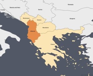
Albania Map and Bordering Countries
Albania is bordered by Montenegro to the northwest, Kosovo to the northeast, North Macedonia to the east, and Greece to the southeast and south. To the west and southwest, it is bordered by the Adriatic and Ionian seas, respectively.
Geography of Albania
If you visit Albania, you will be captivated by its stunning scenery. The Shal River, the Grunas Waterfall, and the village of Theth attract hikers to this national park in the Albanian Alps, offering breathtaking landscapes and a rich history to explore. The Drin, at approximately 280 km, is the longest river in Albania.
Tirana is the capital city. The country has an area of 28,748 sq km with a population of over 2.7 million. The majority of its population is Muslim because of centuries of Ottoman rule. About 17% of the population is Christians.
History of Albania
After World War II, Albania became a Stalinist, isolationist state under Enver Hoxha, until it began transitioning to democracy in 1990. Today, many Albanians leave the country in search of employment, and the remittances they send back form a significant source of income for Albania.
Albania Geography: Watch now
Argentina is the second-largest country in South America
Australia is Known as the largest island on Earth: Watch now
Antigua and Barbuda Geography: watch now