


- Area: 2,381,740 square kilometres
- Population: 6 million
- Capital: Algiers
Algeria, an African country spanning 2,381,740 square kilometres, is home to around 46 million people.
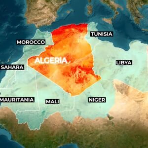
Algeria Map and Bordering Countries
Algeria is bordered by Tunisia to the northeast, Libya to the east, Niger and Mali to the south, Mauritania and the Western Sahara territory to the southwest, and Morocco to the west. To the north, it has a coastline along the Mediterranean Sea.
Geography of Algeria
let us know about the geography of Algeria. It is the largest country in Africa and the 10th largest in the world. The Sahara Desert covers over 80% of the land, yet most Algerians live along the northern coast. Ahaggar Mountains Located in the central part of the country.
Climate of Algeria
If Algeria’s coastal areas enjoy a Mediterranean climate with mild, wet winters and hot, dry summers, then it’s ideal for agriculture and tourism. But while the coastal region is temperate, the Sahara region experiences an extreme desert climate with scorching daytime temperatures and significant drops at night, creating a harsh but fascinating environment.
Angola big country in Africa.
History of Algeria
During its fight for independence from France in the 1950s and 60s, over 1 million Algerians might have died, which is why the country is often referred to as the ‘Country of a Million Martyrs.’
Algeria Geography: Watch now
know more about Australia
A hidden gem nestled in the mountains of Europe Watch now