


- Area: 1,246,700 sq km;
- Population: 34.7 million;
- Capital: Luanda.
- Borders: Republic of Congo, DRC, Zambia, Namibia; Atlantic Ocean.
- Major river: Kwanza River.
- Economy: Rapid growth despite a history of civil wars.
Major oil-producing Country: Angola
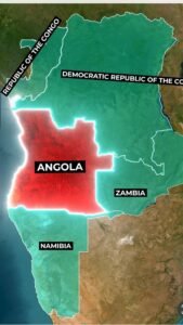
Angola Map and Bordering Countries of Angola
Angola shares borders with the Republic of the Congo to the northwest, the Democratic Republic of the Congo to the north and northeast, Zambia to the southeast, Namibia to the south, and the Atlantic Ocean to the west.
Angola, a big country in Africa, is known for its natural wealth and is a top oil producer. Its capital is Luanda, which covers an area of 1,246,700 sq km with a population of 34.7 million.
Geography of Angola Country
The Kwanza River, a major river in Angola, flows into the Atlantic Ocean near Luanda.
History of Angola Country
Despite a history of civil wars
Angola is now experiencing rapid economic growth.
Angola, a big country in Africa
The sixth-largest country – Australia
A hidden gem nestled in the mountains of Europe – Andorra Country
One of the oldest civilizations in the world: Watch now